Search
Now showing items 11-20 of 26

South Africa
Coloured map.
Line scale given.
First ed. of this map appeared in 1847 but this differs from it, eg. Natal is divided into 4 districts; the northern boundary is taken to the Orange & Vaal rivers. According to the address ...

South Africa
Coloured map 52x85 (dissected) fold. to 19x11cm.
First ed. of this map appeared in 1847 but this differs from it ego Natal is divided into 6 districts; the northern boundary is taken to the Orange & Vaal rivers. According ...

Carte de la coste orientale d'Afrique
Unidentified coloured chart.
Scale not given.
Cartouche is a design in simple scroll work & an 8 point compass rose in the right hand lower corner is the only decoration.
Longitude of the "Isle de Fer" is noted in the ...

South Africa
Coloured map.
Line scale given.
This ed. has considerable additions to the 1st ed. of 1847 eg. Transvaal Republic is named & the Cape redrawn to show 4 new counties.
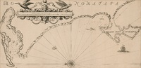
A draught of Cape Bona Esperanca
Chart.
Line scale given.
Proof copy, - lines drawn to guide the lettering are still there.

A new and improved chart of the Cape of Good Hope, the Mozambique Passage & c.
Chart.
At foot, bottom left: Drawn by J. Norie, Teacher of Navigation, No. 157, Leadenhall Street.
Insets: 5, and below them "A View of the Cape of Good Hope"; 1, A New Chart of Delagoa Bay, by Mr. James Stuart. - 2,... ...

Cape District Cape of Good Hope
(Jas. Wyld, 1838)
Coloured map.
Line scale given.
This is a later ed. of De La Rochette's map of 1795, "The Dutch Colony of the Cape of Good Hope, 2nd ed."
The names of De La Rochette & the engraver are omitted & the title is changed, ...

Nieuwe Kaart van de Kaap der Goede Hoope en der na by gelegen Landen
(Is. Tirion, 1763)
Coloured map.
Line scale given in bottom left corner in "Fransche Toises, of halve Roeden."
This map (uncoloured) appears in "Hedendaagsche historie of tegenwoordige staat van Afrika", pub. Amsterdam, I. Tirion, 1763, p.683.

Plan of harbour for Table Bay, Cape of Good Hope
Coloured plan.
Line scale given, also for inset.
In top right corner, "From the Admiralty Survey, by Capt. Edwd. Belcher R.N.C.B. 1846."
Inset: A chart of Table Bay including Robben Island, in bottom right corner.

A plan of Cape Bona Esperance
(Laurie & Whittle, 1794)
Chart.
Line scale given.
Simple cartouche in centre & above it 6 "Views of the land". There are no decorations but an 8 point compass rose drawn in the bay.
Inset: "Advertisement" to right of cartouche, giving information ...