Browsing Images by Title
Now showing items 41-60 of 3717
-
Africa imagined : a selection of maps from the Hugh Solomon Collections Stellenbosch University Library and Information Service
An introduction on the Hugh Solomon map collection and descriptions and depictions of 18 selected maps from the collection. -
Africa Secundum legitimas Projectionis Stereographicae regulas
Coloured map. Scale not given. Title within large cartouche (uncoloured) bottom left with figures of Europeans & natives, lions, elephant, rhinoceros etc. This map is a re-engraving of the 1737 ed. as there are changes ... -
-
Africa, from the latest authorities
(Bungay, Suffolk : C. Brightly & E. Kinnersley, 1806)Coloured map. Scale not given. -
Africae accurata tabula
Coloured map. Scale not given. Title within cartouche top right, with a negro on either side & 2 angels below. Decorative dedication bottom left, to Gerard Schaep. At foot of map on the right: Cum Privilegio Ordin: ... -
Africae nova descriptio
Coloured map. Scale not given. Latin text on the reverse (incomplete) differs from that of Atlas major pub. by his son Johan Blaeu in 1662. This map may be from an ed. of the Appendix theatri... first pub. in 1631, or ... -
Africae pars meridionalis cum promontorio Bonae Spei
Coloured map. Scale not given. 3 insets at foot of map: in left corner, "Castellum Batavorum in Promontorio Bonae Spei of het Casteel de Goede Hoop"; in right corner, "Sinus Saldanhae or Saldanha Bay", & "Ager Prbmontorii ... -
Africae propriae tabula
Coloured map. Scale not given. First appeared in theatrum orbis terrarum, Addimentum IV (parergon) of 1591. At the bottom of the map in 2 decorated insets are a plan of Carthage and a list of sources. Latin text on ... -
Africae Tabula Nova
Coloured map. Scale not given. col.map 37x50cm. First appeared in A. Ortelius: Theatrum orbis terrarum of 1570. Simple cartouche with 2 armless statues of women; above the title is inscribed: Africam Graeci Lybyam ... -
The African crocodile hunters
Depicting a native figure, holding a knife in one hand, with the other (guarded) arm in the mouth of a crocodile in a river. Palm trees and two other figures in the background. -
-
The African rhinoceros
Large rhinoceros in foreground with two rhinos being hunted in the background. -
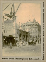
Afrika Bank (Marktplein) Johannesburg
(Haagsche Pro-Boer Vereeniging, 1900)Photograph depicting Afrika Bank (Market Square) in Johannesburg. -
L'Afrique
Coloured map. Scale not given. Large decorative title piece bottom left copied from Homan Heirs map in reverse. Inset: Notes on Africa in top left corner. -
L'Afrique
(Hubert Jaillot, 1674)Coloured map. Line scale given. Title above top border: L'Afrique distinguée en ses principales parties... -
L'Afrique
Coloured map. Scale not given. "Possibly from the maps accompanying Du Val's "Geographia universalis", pub. in Nuremberg in 1685", Johannesburg Pub. Lib: Exhibition of decorative maps of Africa up to 1800, 1952, descriptive ... -
L'Afrique divisee en ses principaux etats
Coloured map. Scale not given. Above top right corner: No. 28 Title within cartouche bottom left with palm trees, crocodile etc. -
L'Afrique dressee
Coloured map. 3 line scales given. In bottom right hand corner: Guill. Delahaye Sculpsit. Cartouche in top right corner depicting a native woman, on the left, reclining between 2 palms & leaning on an elephant's head, ... -
Afrique meridionale
Coloured map. Line scales given. Above top right corner: Atlas, en 65 feuilles, No. 53 Author of map is not given but on left centre side a circle with the words "Carte encyprotipe" is stamped; within this is printed: ... -
L'Afrique Suivant les Nouvelles Observations
Map. Line scale given. map 23x30cm. Decorated cartouche with title in top right corner showing elephants, a rider on horseback, a native riding a crocodile.