Search
Now showing items 11-20 of 81

A new map of Africa from the latest authorities
(J. Cary, 1805)
Coloured map.
Scale not given.

Africa
(Cadell & Davies, 1811)
Coloured map.
Scale not given.

Cape District Cape of Good Hope
(Jas. Wyld, 1838)
Coloured map.
Line scale given.
This is a later ed. of De La Rochette's map of 1795, "The Dutch Colony of the Cape of Good Hope, 2nd ed."
The names of De La Rochette & the engraver are omitted & the title is changed, ...

Algemeene kaart, van de Colonie de Kaap de Goede Hoop
(Mortier Covens en Zoon, 1806)
Coloured map.
Line scale given.
This may be an enlargement of the map which appears in B.P. Bouchenroeder: Reize in de Binnenland van Zuid-Afrika, 1803. Mortier Covens en Zoon, 1806.

A map of the European territory of the Cape of Good Hope
(H. Colburn, 1815)
Map of the Cape of Good Hope.

Natal and Kaffraria
(Tallis (John) & Co., 1851)
Coloured map.
Line scale given.
2 inset vignettes: "Entrance to Port Natal", and Town of Durban with medallion above of the seal of Natal.
Some boundaries have been added by hand in water colour, in blue and yellow.

Africa
(Wilkie & Robinson, 1811)
Coloured map.
Scale not given.
In lower left corner: J. Russell del. et sculp.
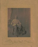
‘n Man sittend op ‘n stoel buite ‘n gebou, met ‘n geweer in sy regterhand en ‘n hond langs hom
(1896)
Photograph depicting a man sitting on a chair outside a building, with a rifle in his right hand and a dog next to him. Inscription at the bottom of the photo: Battle of Doornkop at Krugersdorp, Transvaal, 2 January 1896. ...
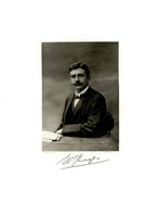
Willem Johannes Leyds
(1899)
Photograph depicting Willem Johannes Leyds.
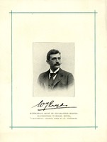
Willem Johannes Leyds
(1899)
Photograph depicting Willem Johannes Leyds.