Images: Recent submissions
Now showing items 3341-3360 of 3792
-
Paskaart van de Zuyd-west-kust van Africa
(Jodocus Hondius, 1652)Coloured chart. Line scale given for inset. Inset in top left corner has no title but is an enlarged chart of the coast between St. Helena & False Bay. Smaller inset next to it, is an enlargement of Vlees (Mossel) Bay. ... -
Cape District Cape of Good Hope
(Jas. Wyld, 1838)Coloured map. Line scale given. This is a later ed. of De La Rochette's map of 1795, "The Dutch Colony of the Cape of Good Hope, 2nd ed." The names of De La Rochette & the engraver are omitted & the title is changed, ... -
Plan of harbour for Table Bay, Cape of Good Hope
Coloured plan. Line scale given, also for inset. In top right corner, "From the Admiralty Survey, by Capt. Edwd. Belcher R.N.C.B. 1846." Inset: A chart of Table Bay including Robben Island, in bottom right corner. -
The Dutch Colony of the Cape of Good Hope
(W. Faden, 1782)Map, coloured border. Line scales given. Depicts an area from Klipping Eyland to Caap Falso bounded on the east by the Draakenstein mountains. Lettered table of place names on the left. -
Carte reduite d'une partie des Costes Occidentales et Meridionales de l'Afrique
Chart. Scale not given. Title within large cartouche bottom left, surmounted by the arms of France. 3 silhouettes of the coast top right: Vue du Cap de Bonne Esperance, Vue du Cap Falso, Autre Vue du Cap Falso. This ... -
Carte de L'Isle de Madagascar
Map. Line scales given. Title in plain cartouche bottom left. Plate number top right: No. 93 Stamp in bottom right corner: Depot de la Marine, with the fleur de lys; below the map is the price - trente Sols. Inset: ... -
A new and accurate map of Africa
Coloured map. At top of map: Engraved for Bankes's New System of Geography, Published by Royal Authority. First appeared in Middelton's "New and Complete system of Geography", 1777-78, and was reissued for Bankes "Geography" ... -
L'Afrique
Coloured map. Scale not given. Large decorative title piece bottom left copied from Homan Heirs map in reverse. Inset: Notes on Africa in top left corner. -
Carte de L'Isle de France
Map. Line scales given. Title within decorated cartouche bottom right. Lower right below map: P.A. Rameau, fecit 1763. Plate number top right: No. 94 Stamp on left: Depot de la Marine, with the fleur de lys; below the ... -
Africae pars meridionalis cum promontorio Bonae Spei
Coloured map. Scale not given. 3 insets at foot of map: in left corner, "Castellum Batavorum in Promontorio Bonae Spei of het Casteel de Goede Hoop"; in right corner, "Sinus Saldanhae or Saldanha Bay", & "Ager Prbmontorii ... -
Carte d'Afrique
Map. Title above top of map: Africa accurate in imperia regna, status & populos divisa, ad usum Ludovici XV Galliarum regis. In bottom right corner: J. Kondet Schulpsit. This a Dutch ed. of De l'Isle's revised map of ... -
Occidentalior Tractus Indiarum Orientalium à Promontorio Bonae Spei ad C. Comorin
Coloured chart. Line scale given. col.chart 45x54cm. Elaborate cartouche in bottom left corner with figures and animals. Possibly from the sea atlas issued by de Wit c1680. -
Carte de l'Isle de Bourbon
Map. Line scale given. Title within decorated car touche top left. Plate number top right: No. 95 Stamp in bottom right corner: Depot de la Marine, with the fleur de lys; below the map is the price - trente Sols. ... -
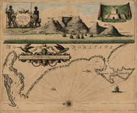
A draught of Cape Bona Esperanca
Coloured chart. Line scale given. Title within decorated cartouche is in top left corner & in top right is an inset of a fort; running across the top of the map is a view of Table Bay. Map has a large decorative scale ... -
A map of Africa
Coloured map. Line scale given. col.map 49x57cm. Inset: Table of the European possessions in Africa. Appears in: A general atlas of Thirty Six new and Correct Maps by Palairet and Others executed by Carington Bowles... 1769. -
Map of Africa with the latest discoveries
Coloured map. Line scales given. Insets: Azores or Western Islands. - Observation. This is still basically the De La Rochette map of 1803 but considerably revised since the eds. Of 1803-1855 eg. Transvaal Republic and ... -
Carte generale de l'Afrique
Coloured map. Line scales given. Above top right corner: Atlas, en 65, 56 feuil1es No. 51, 30. In bottom left corner are line scales and a note. -
-
Map of Africa with the latest discoveries
(Jas. Wyld, 1841)Coloured map. Line scales given. Insets: Azores or Western Island. - Observation. First ed. of this map was pub. by W. Faden in 1803 & a 2nd & later eds. by J. Wyld from 1803 onwards. In this 1841 ed. for the first ... -
Africae accurata tabula
Coloured map. Scale not given. Title within cartouche top right, with a negro on either side & 2 angels below. Decorative dedication bottom left, to Gerard Schaep. At foot of map on the right: Cum Privilegio Ordin: ...