Images: Recent submissions
Now showing items 3361-3380 of 3792
-
South Africa
Coloured map. Line scale given. First ed. of this map appeared in 1847 but this differs from it, eg. Natal is divided into 4 districts; the northern boundary is taken to the Orange & Vaal rivers. According to the address ... -
Africa
Coloured map. No imprint, no date. This appears to be the same map listed by R. Tooley in his "Collectors' guide to maps of the African continent... 1969, p.117. It was first pub. in 1813 & another ed. with imprint & ... -
South Africa
Coloured map. Line scale given. This ed. has considerable additions to the 1st ed. of 1847 eg. Transvaal Republic is named & the Cape redrawn to show 4 new counties. -
A new map of Africa from the latest observations
Coloured map. Appears in J. Senex: A new general atlas of the world, London, 1721. -
-
A draught of Cape Bona Esperanca
Chart. Line scale given. Proof copy, - lines drawn to guide the lettering are still there. -
L'Afrique
Coloured map. Scale not given. "Possibly from the maps accompanying Du Val's "Geographia universalis", pub. in Nuremberg in 1685", Johannesburg Pub. Lib: Exhibition of decorative maps of Africa up to 1800, 1952, descriptive ... -
Isle d'Auphine
Coloured map. Line scale given. Appears (uncoloured) in E. Klemp: Africa on maps dating from the 12th to the 18th century, 1968 (No. 73). -
De l'Afrique
Coloured map. Scale not given. On either side of map is a description of Africa in French which is headed "De l'Afrique.” A plain map with no decoration, no title or indication of its author or source. In southern Africa ... -
-
Carte reduite du canal de Mozambique et des Isles de Madagascar de France de Bourbon
Chart. Line scales given. Title within decorated cartouche top left. Plate number top right: No. 92. Stamp in bottom right corner: Depot de la Marine, with the Fleur de lys; below the map is the price - trente Sols. ... -
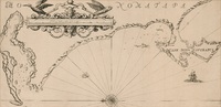
A plan of Cape Bona Esperance
(Laurie & Whittle, 1794)Chart. Line scale given. Simple cartouche in centre & above it 6 "Views of the land". There are no decorations but an 8 point compass rose drawn in the bay. Inset: "Advertisement" to right of cartouche, giving information ... -
Algemeene kaart, van de Colonie de Kaap de Goede Hoop
(Mortier Covens en Zoon, 1806)Coloured map. Line scale given. This may be an enlargement of the map which appears in B.P. Bouchenroeder: Reize in de Binnenland van Zuid-Afrika, 1803. Mortier Covens en Zoon, 1806. -
A draught of Cape Bona Esperanca
Chart. Line scale given. This map with some changes is a new ed. of that issued by John Seller in 1675. Seller & Thornton collaborated from 1675 onwards & produced several works including “The English pilot" in which ... -
L'Afrique dressee
Coloured map. 3 line scales given. In bottom right hand corner: Guill. Delahaye Sculpsit. Cartouche in top right corner depicting a native woman, on the left, reclining between 2 palms & leaning on an elephant's head, ... -
Africa
(Wilkie & Robinson, 1811)Coloured map. Scale not given. In lower left corner: J. Russell del. et sculp. -
Africae nova descriptio
Coloured map. Scale not given. Latin text on the reverse (incomplete) differs from that of Atlas major pub. by his son Johan Blaeu in 1662. This map may be from an ed. of the Appendix theatri... first pub. in 1631, or ... -
Africa
Coloured map. Scale not given. Title is given in bottom right corner & is not enclosed in a cartouche. On lower left side are 2 notes, 1 on "St. Helena” & the other on the "Cape of Good Hope". In the middle of Africa ... -
Africae Tabula Nova
Coloured map. Scale not given. col.map 37x50cm. First appeared in A. Ortelius: Theatrum orbis terrarum of 1570. Simple cartouche with 2 armless statues of women; above the title is inscribed: Africam Graeci Lybyam ... -
Africa Secundum legitimas Projectionis Stereographicae regulas
Coloured map. Scale not given. Title within large cartouche (uncoloured) bottom left with figures of Europeans & natives, lions, elephant, rhinoceros etc. This map is a re-engraving of the 1737 ed. as there are changes ...