Browsing Images by Title
Now showing items 18-37 of 3717
-
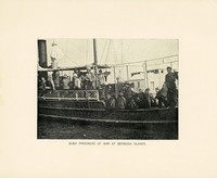
Aankoms by die hawe van sleepboot met Britse soldate en krygsgevangenes
(1900)Photograph depicting British soldiers and prisoners of war, arriving on a tugboat at the harbour at Bermuda Islands. -
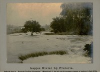
Aapjes rivier bij Pretoria
(Haagsche Pro-Boer Vereeniging, 1900)Photograph depicting the Apies River at Pretoria. -
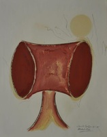
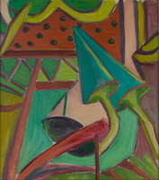
Abstract head
(1991) -
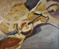
Abstrak 1
(1982) -
Abstrakte komposisie
(1955) -
Abstrakte komposisie
(1955) -
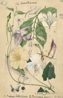
Acanthaceae
(1932)Plate 44 from The flora of South Africa (vol. 3, part 2) featuring Acanthaceae. -
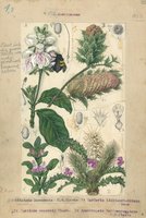
Acanthaceae
(1932)Plate 45 from The flora of South Africa (vol. 3, part 2) featuring Acanthaceae. -
-
Acquiescence
(1971) -
Actor
(1960) -
Aegyptus antiqua
Coloured map. First appeared in Theatrum orbis terrarum, Additamentum V (Parergon)of 1595. 2 insets, 1 giving details of the coast between Alexandria and Heraclium; the other inset oval in shape and coloured yellow, ... -
Aethiopia Inferior, vel Exterior
Coloured map. Line scale given. Title cartouche in bottom right corner, an ox skin supported by 2 natives with tortoises and monkeys at the foot. Two ships are shown off the west coast & 1 off the east coast. This map ... -
Aethiopia Inferior, vel Exterior
Coloured map. Line scale given. Title cartouche in bottom right corner, on ox skin supported by 2 natives with tortoises and monkeys at the foot. Two ships are shown off the west coast & 2 more off the east coast. This ... -
Aevi veteris, typus geographicus
Coloured map. Scale not given. Title at foot of map: En spectator, pilae totius terrae inchnographiam... Map is in form of a globe with a decorated border with circular insets in each corner (Europe, America, Asia and ... -
Africa
Coloured map. Scale not given. Title is given in bottom right corner & is not enclosed in a cartouche. On lower left side are 2 notes, 1 on "St. Helena” & the other on the "Cape of Good Hope". In the middle of Africa ... -
Africa
Coloured map on sheet 35x22cm. On verso: Barbary and Bildulgerid; A map of Zaara. Negroe-land. Guinea... Page number top right, 133; headed "A general and particular description of Africa." This sheet of maps ... -
Africa
(John Tallis & Company, 1851)Coloured map. Differs from 1st ed. of 1850, e.g. bounds of Cape Colony have been extended to Orange River & some names have been altered - Maravi to Nyassi etc. 5 inset vignettes. Some boundaries have been added by ... -
Africa
Coloured map. Line scale given. A Copy of this map, with J. Senex's name as well as Price’s, also dated 1711, is described by R.V. Tooley in his "Collectors' guide to maps of Africa," 1969, p.108. There are differences ... -
Africa
Coloured map. No imprint, no date. This appears to be the same map listed by R. Tooley in his "Collectors' guide to maps of the African continent... 1969, p.117. It was first pub. in 1813 & another ed. with imprint & ...