Browsing Images by Title
Now showing items 845-864 of 3717
-
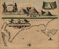
A draught of Cape Bona Esperanca
Coloured chart. Line scale given. Title within decorated cartouche is in top left corner & in top right is an inset of a fort; running across the top of the map is a view of Table Bay. Map has a large decorative scale ... -
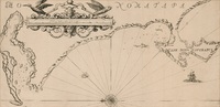
A draught of Cape Bona Esperanca
Chart. Line scale given. Proof copy, - lines drawn to guide the lettering are still there. -
A draught of Cape Bona Esperanca
Chart. Line scale given. This map with some changes is a new ed. of that issued by John Seller in 1675. Seller & Thornton collaborated from 1675 onwards & produced several works including “The English pilot" in which ... -
Drawing a cord through pierced reeds
Photograph depicting a woman drawing a cord through pierced reeds, which are used to build matjieshuise. -
Drawing I
(1976) -
Drawing II
(1976) -
-
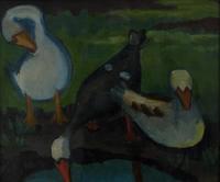
Drie ganse
(1934) -
-
Driefontein, Fraserburg, threshing floor and a corbelled wheat store
Photograph depicting a threshing floor and a corbelled wheat store at Driefontein, Fraserburg. -
The drive to the runner-stone
Drawing of the drive to the runner-stone, depicting detail of (a) Roux Pos: a damsel, a flat rynd, and a stone-spindle, (b) Matjes Rivier: a damsel, a three-armed rynd, a stone-spindle and a lantern, (c) Elim: a damsel, a ... -
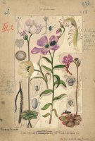
Droseraceae
(1925)Plate 66 from The flora of South Africa (vol. 2, part 2) featuring Droseraceae. -
-
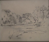
Dry river bed, Sabie
(1925) -
The Dutch Colony of the Cape of Good Hope
(W. Faden, 1782)Map, coloured border. Line scales given. Depicts an area from Klipping Eyland to Caap Falso bounded on the east by the Draakenstein mountains. Lettered table of place names on the left. -
-
Dwarsrivierhoek fowl-house, nesting-places
Photographs depicting nesting-places in the Dwarsrivierhoek fowl-house. -
Dwarsrivierhoek, Banghoek, fowl-house
Photograph depicting the fowl-house at Dwarsrivierhoek, Banghoek. -
Dzata, Transvaal
Drawing of Dzata, based on a sketch plan by J.F. Schofield, 1942, with minor additions by James Walton, 1953. The drawing depicts detail of the occupational area, a stockade, 3 mounds, a hut of the principal wife, a sacred ... -
Early Bantu mullers
Drawing of early Bantu mullers, depicting detail of mullers at Knecht's Kloof, Zastron and Metlaeeng, Lesotho.