Browsing Hugh Solomon Map Collection by Title
Now showing items 48-67 of 97
-
De l'Afrique
Coloured map. Scale not given. On either side of map is a description of Africa in French which is headed "De l'Afrique.” A plain map with no decoration, no title or indication of its author or source. In southern Africa ... -
A draught of Cape Bona Esperanca
Coloured chart. Line scale given. Title within decorated cartouche is in top left corner & in top right is an inset of a fort; running across the top of the map is a view of Table Bay. Map has a large decorative scale ... -
A draught of Cape Bona Esperanca
Chart. Line scale given. Proof copy, - lines drawn to guide the lettering are still there. -
A draught of Cape Bona Esperanca
Chart. Line scale given. This map with some changes is a new ed. of that issued by John Seller in 1675. Seller & Thornton collaborated from 1675 onwards & produced several works including “The English pilot" in which ... -
The Dutch Colony of the Cape of Good Hope
(W. Faden, 1782)Map, coloured border. Line scales given. Depicts an area from Klipping Eyland to Caap Falso bounded on the east by the Draakenstein mountains. Lettered table of place names on the left. -
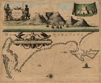
False Bay (sea chart). [unidentified]
Manuscript coloured chart. Decorated cartouche with title is towards the lower right. On the right of this is an empty decorated frame, probably intended for a dedication. Below this are 2 drawings of the mountains of ... -
-
Geographia sacra
Coloured map. [Scale not given] 3 decorated insets:- 1, Giving authorities.- 2, Map of the world.- 3, In bottom right corner: Reverendo et illustridno Gulielmo Grimbergio, Antverpiensi praesuli dignissimo... This map ... -
Grahams Town and the out posts
(James Wyld, 1851)Coloured map. London. Published by James Wyld. Geographer to the Queen & H.R.H. Prince Albert, Charing Cross East. 3rd edition May 3rd., 1851. Below map: Pubd. by Jas. Wyld. March 6th. 1851. -
Isle d'Auphine
Coloured map. Line scale given. Appears (uncoloured) in E. Klemp: Africa on maps dating from the 12th to the 18th century, 1968 (No. 73). -
Map of Africa
Map. Scale not given. 4 inset views along base of map, on left, Cape Coast Castle, James Fort St. Helena, Fort of Good Hope; and on the right, Prospect of the Cape of Good Hope. -
A map of Africa
Coloured map. Line scale given. col.map 49x57cm. Inset: Table of the European possessions in Africa. Appears in: A general atlas of Thirty Six new and Correct Maps by Palairet and Others executed by Carington Bowles... 1769. -
Map of Africa
Coloured map. Scale not given. 4 inset views along base of map, on left, Cape Coast Castle, James Fort St. Helena, Fort of Good Hope; and on the right, Prospects of the Cape of Good Hope. This ed. has Moll's name removed ... -
Map of Africa
Coloured map. Scale not given. 4 inset views along base of map on left, Cape Coast Castle, James Fort St. Helena, Fort of Good Hope; and on the right, Prospect of the Cape of Good Hope. -
Map of Africa with the latest discoveries
Coloured map. Line scales given. Insets: Azores or Western Islands. - Observation. This is still basically the De La Rochette map of 1803 but considerably revised since the eds. Of 1803-1855 eg. Transvaal Republic and ... -
Map of Africa with the latest discoveries
(Jas. Wyld, 1841)Coloured map. Line scales given. Insets: Azores or Western Island. - Observation. First ed. of this map was pub. by W. Faden in 1803 & a 2nd & later eds. by J. Wyld from 1803 onwards. In this 1841 ed. for the first ... -
A map of the European territory of the Cape of Good Hope
(H. Colburn, 1815)Map of the Cape of Good Hope. -
A map of Zaara. Negroe-land. Guinea & c.
Coloured map on sheet. Lower half of a sheet with "Barbary and Bildurgerid"; on verso, "Africa." Page number top left, 134, headed "Africa". Inset: The Isles of C. Verd. This sheet of maps (uncoloured) appears in ... -
A mapp of the higher and lower Aethiopia
Map. In top right corner is a heraldic dedication to Sr. William Glynne of Bissister, signed R.B. In lower right corner: Francis Lamb Sculp. This map is an exact copy on a slightly smaller scale of Sanson's map of ... -
Natal and Kaffraria
(Tallis (John) & Co., 1851)Coloured map. Line scale given. 2 inset vignettes: "Entrance to Port Natal", and Town of Durban with medallion above of the seal of Natal. Some boundaries have been added by hand in water colour, in blue and yellow.