Browsing Hugh Solomon Map Collection by Title
Now showing items 1-20 of 97
-
Aegyptus antiqua
Coloured map. First appeared in Theatrum orbis terrarum, Additamentum V (Parergon)of 1595. 2 insets, 1 giving details of the coast between Alexandria and Heraclium; the other inset oval in shape and coloured yellow, ... -
Aethiopia Inferior, vel Exterior
Coloured map. Line scale given. Title cartouche in bottom right corner, an ox skin supported by 2 natives with tortoises and monkeys at the foot. Two ships are shown off the west coast & 1 off the east coast. This map ... -
Aethiopia Inferior, vel Exterior
Coloured map. Line scale given. Title cartouche in bottom right corner, on ox skin supported by 2 natives with tortoises and monkeys at the foot. Two ships are shown off the west coast & 2 more off the east coast. This ... -
Aevi veteris, typus geographicus
Coloured map. Scale not given. Title at foot of map: En spectator, pilae totius terrae inchnographiam... Map is in form of a globe with a decorated border with circular insets in each corner (Europe, America, Asia and ... -
Africa
Coloured map. Scale not given. Title is given in bottom right corner & is not enclosed in a cartouche. On lower left side are 2 notes, 1 on "St. Helena” & the other on the "Cape of Good Hope". In the middle of Africa ... -
Africa
Coloured map on sheet 35x22cm. On verso: Barbary and Bildulgerid; A map of Zaara. Negroe-land. Guinea... Page number top right, 133; headed "A general and particular description of Africa." This sheet of maps ... -
Africa
(John Tallis & Company, 1851)Coloured map. Differs from 1st ed. of 1850, e.g. bounds of Cape Colony have been extended to Orange River & some names have been altered - Maravi to Nyassi etc. 5 inset vignettes. Some boundaries have been added by ... -
Africa
Coloured map. Line scale given. A Copy of this map, with J. Senex's name as well as Price’s, also dated 1711, is described by R.V. Tooley in his "Collectors' guide to maps of Africa," 1969, p.108. There are differences ... -
Africa
Coloured map. No imprint, no date. This appears to be the same map listed by R. Tooley in his "Collectors' guide to maps of the African continent... 1969, p.117. It was first pub. in 1813 & another ed. with imprint & ... -
-
Africa
(Wilkie & Robinson, 1811)Coloured map. Scale not given. In lower left corner: J. Russell del. et sculp. -
Africa according to Mr. D'Anville
(Robert Sayer, 1772)Coloured map. Line scales given. Insets: Azores, and A chart of the Gold Coast; Long geographic descriptions (incl. full particulars about the Cape) are placed in every available space. Geographically this map is practically ... -
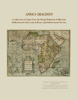
Africa imagined : a selection of maps from the Hugh Solomon Collections Stellenbosch University Library and Information Service
An introduction on the Hugh Solomon map collection and descriptions and depictions of 18 selected maps from the collection. -
Africa Secundum legitimas Projectionis Stereographicae regulas
Coloured map. Scale not given. Title within large cartouche (uncoloured) bottom left with figures of Europeans & natives, lions, elephant, rhinoceros etc. This map is a re-engraving of the 1737 ed. as there are changes ... -
-
Africa, from the latest authorities
(Bungay, Suffolk : C. Brightly & E. Kinnersley, 1806)Coloured map. Scale not given. -
Africae accurata tabula
Coloured map. Scale not given. Title within cartouche top right, with a negro on either side & 2 angels below. Decorative dedication bottom left, to Gerard Schaep. At foot of map on the right: Cum Privilegio Ordin: ... -
Africae nova descriptio
Coloured map. Scale not given. Latin text on the reverse (incomplete) differs from that of Atlas major pub. by his son Johan Blaeu in 1662. This map may be from an ed. of the Appendix theatri... first pub. in 1631, or ... -
Africae pars meridionalis cum promontorio Bonae Spei
Coloured map. Scale not given. 3 insets at foot of map: in left corner, "Castellum Batavorum in Promontorio Bonae Spei of het Casteel de Goede Hoop"; in right corner, "Sinus Saldanhae or Saldanha Bay", & "Ager Prbmontorii ... -
Africae propriae tabula
Coloured map. Scale not given. First appeared in theatrum orbis terrarum, Addimentum IV (parergon) of 1591. At the bottom of the map in 2 decorated insets are a plan of Carthage and a list of sources. Latin text on ...