Browsing Hugh Solomon Map Collection by Issue Date
Now showing items 41-60 of 97
-
Geographia sacra
Coloured map. [Scale not given] 3 decorated insets:- 1, Giving authorities.- 2, Map of the world.- 3, In bottom right corner: Reverendo et illustridno Gulielmo Grimbergio, Antverpiensi praesuli dignissimo... This map ... -
Africa
Coloured map on sheet 35x22cm. On verso: Barbary and Bildulgerid; A map of Zaara. Negroe-land. Guinea... Page number top right, 133; headed "A general and particular description of Africa." This sheet of maps ... -
A new and accurate map of Africa
Coloured map. At top of map: Engraved for Bankes's New System of Geography, Published by Royal Authority. First appeared in Middelton's "New and Complete system of Geography", 1777-78, and was reissued for Bankes "Geography" ... -
L'Afrique
Coloured map. Scale not given. Large decorative title piece bottom left copied from Homan Heirs map in reverse. Inset: Notes on Africa in top left corner. -
Carte de L'Isle de France
Map. Line scales given. Title within decorated cartouche bottom right. Lower right below map: P.A. Rameau, fecit 1763. Plate number top right: No. 94 Stamp on left: Depot de la Marine, with the fleur de lys; below the ... -
Africae pars meridionalis cum promontorio Bonae Spei
Coloured map. Scale not given. 3 insets at foot of map: in left corner, "Castellum Batavorum in Promontorio Bonae Spei of het Casteel de Goede Hoop"; in right corner, "Sinus Saldanhae or Saldanha Bay", & "Ager Prbmontorii ... -
Carte d'Afrique
Map. Title above top of map: Africa accurate in imperia regna, status & populos divisa, ad usum Ludovici XV Galliarum regis. In bottom right corner: J. Kondet Schulpsit. This a Dutch ed. of De l'Isle's revised map of ... -
Occidentalior Tractus Indiarum Orientalium à Promontorio Bonae Spei ad C. Comorin
Coloured chart. Line scale given. col.chart 45x54cm. Elaborate cartouche in bottom left corner with figures and animals. Possibly from the sea atlas issued by de Wit c1680. -
Carte de l'Isle de Bourbon
Map. Line scale given. Title within decorated car touche top left. Plate number top right: No. 95 Stamp in bottom right corner: Depot de la Marine, with the fleur de lys; below the map is the price - trente Sols. ... -
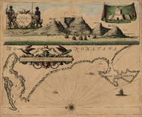
The Bay of Agoa de Saldanha
Coloured map. Line scale given. Lower half of a sheet with "St. Helena..." Page number top right: 43 Appeared in eds. pub. 1729-1735 of H. Moll's “Atlas minor”. 1732 is written in pencil in bottom left corner. -
Romani imperii imago
Coloured map. Scale not given. First appeared in A. Ortelius: Theatrum orbis terrarum, Parergon, of 1579. Ortelius's name is not given on this map, nor a date. Insets: 2 giving authorities; a genealogical table; 2 ... -
Map of Africa
Map. Scale not given. 4 inset views along base of map, on left, Cape Coast Castle, James Fort St. Helena, Fort of Good Hope; and on the right, Prospect of the Cape of Good Hope. -
A draught of Cape Bona Esperanca
Coloured chart. Line scale given. Title within decorated cartouche is in top left corner & in top right is an inset of a fort; running across the top of the map is a view of Table Bay. Map has a large decorative scale ... -
Partie de l'Afrique audelá de l'Equateur, Comprenant le Congo, la Cafrerie &c.
Coloured map. Paris, chez le Sr. Desnos... 1766 "This map may originally have formed part of Brion de la Tour's "Atlas général..., issued in Paris in 1767", Johannesburg Pub. Lib.: Exhibition of decorative maps of Africa ... -
A new & accurate map of the Southern parts of Africa
Coloured map. Line scale given in English and French Leagues. First appeared in 1747 and was reissued in 1752 and 1766. It also appeared (uncoloured) in E. Bowen: A complete atlas... of the known world; also in his ... -
North Africa
Coloured maps. Upper half of a sheet with "South Africa." Shows routes taken by Browne, Horneman, Bruce, Park. Lower half of a sheet with "North Africa.". Map is extended beyond the top border to include the Orange ... -
-
A map of Africa
Coloured map. Line scale given. col.map 49x57cm. Inset: Table of the European possessions in Africa. Appears in: A general atlas of Thirty Six new and Correct Maps by Palairet and Others executed by Carington Bowles... 1769. -
A new map of Africk
Map. Probably taken from the 1722 ed. of "A new sett of maps" by E. Wells as the figure 37 inscribed twice on top border corresponds to the no. given in this ed. -
Map of Africa with the latest discoveries
Coloured map. Line scales given. Insets: Azores or Western Islands. - Observation. This is still basically the De La Rochette map of 1803 but considerably revised since the eds. Of 1803-1855 eg. Transvaal Republic and ...