Hugh Solomon Map Collection: Recent submissions
Now showing items 61-80 of 97
-
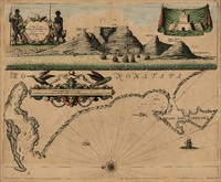
A draught of Cape Bona Esperanca
Coloured chart. Line scale given. Title within decorated cartouche is in top left corner & in top right is an inset of a fort; running across the top of the map is a view of Table Bay. Map has a large decorative scale ... -
A map of Africa
Coloured map. Line scale given. col.map 49x57cm. Inset: Table of the European possessions in Africa. Appears in: A general atlas of Thirty Six new and Correct Maps by Palairet and Others executed by Carington Bowles... 1769. -
Map of Africa with the latest discoveries
Coloured map. Line scales given. Insets: Azores or Western Islands. - Observation. This is still basically the De La Rochette map of 1803 but considerably revised since the eds. Of 1803-1855 eg. Transvaal Republic and ... -
Carte generale de l'Afrique
Coloured map. Line scales given. Above top right corner: Atlas, en 65, 56 feuil1es No. 51, 30. In bottom left corner are line scales and a note. -
-
Map of Africa with the latest discoveries
(Jas. Wyld, 1841)Coloured map. Line scales given. Insets: Azores or Western Island. - Observation. First ed. of this map was pub. by W. Faden in 1803 & a 2nd & later eds. by J. Wyld from 1803 onwards. In this 1841 ed. for the first ... -
Africae accurata tabula
Coloured map. Scale not given. Title within cartouche top right, with a negro on either side & 2 angels below. Decorative dedication bottom left, to Gerard Schaep. At foot of map on the right: Cum Privilegio Ordin: ... -
South Africa
Coloured map. Line scale given. First ed. of this map appeared in 1847 but this differs from it, eg. Natal is divided into 4 districts; the northern boundary is taken to the Orange & Vaal rivers. According to the address ... -
Africa
Coloured map. No imprint, no date. This appears to be the same map listed by R. Tooley in his "Collectors' guide to maps of the African continent... 1969, p.117. It was first pub. in 1813 & another ed. with imprint & ... -
South Africa
Coloured map. Line scale given. This ed. has considerable additions to the 1st ed. of 1847 eg. Transvaal Republic is named & the Cape redrawn to show 4 new counties. -
A new map of Africa from the latest observations
Coloured map. Appears in J. Senex: A new general atlas of the world, London, 1721. -
-
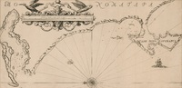
A draught of Cape Bona Esperanca
Chart. Line scale given. Proof copy, - lines drawn to guide the lettering are still there. -
L'Afrique
Coloured map. Scale not given. "Possibly from the maps accompanying Du Val's "Geographia universalis", pub. in Nuremberg in 1685", Johannesburg Pub. Lib: Exhibition of decorative maps of Africa up to 1800, 1952, descriptive ... -
Isle d'Auphine
Coloured map. Line scale given. Appears (uncoloured) in E. Klemp: Africa on maps dating from the 12th to the 18th century, 1968 (No. 73). -
De l'Afrique
Coloured map. Scale not given. On either side of map is a description of Africa in French which is headed "De l'Afrique.” A plain map with no decoration, no title or indication of its author or source. In southern Africa ... -
-
Carte reduite du canal de Mozambique et des Isles de Madagascar de France de Bourbon
Chart. Line scales given. Title within decorated cartouche top left. Plate number top right: No. 92. Stamp in bottom right corner: Depot de la Marine, with the Fleur de lys; below the map is the price - trente Sols. ... -
A plan of Cape Bona Esperance
(Laurie & Whittle, 1794)Chart. Line scale given. Simple cartouche in centre & above it 6 "Views of the land". There are no decorations but an 8 point compass rose drawn in the bay. Inset: "Advertisement" to right of cartouche, giving information ... -
Algemeene kaart, van de Colonie de Kaap de Goede Hoop
(Mortier Covens en Zoon, 1806)Coloured map. Line scale given. This may be an enlargement of the map which appears in B.P. Bouchenroeder: Reize in de Binnenland van Zuid-Afrika, 1803. Mortier Covens en Zoon, 1806.