Browsing Hugh Solomon Map Collection by Title
Now showing items 33-52 of 97
-
-
Cape Colony
(John Tallis & Company, 1851)Coloured map. 5 inset vignettes and a medallion above Cape Town in bottom left corner. Some boundaries have been added by hand in water colour, blue and yellow. -
Cape District Cape of Good Hope
(Jas. Wyld, 1838)Coloured map. Line scale given. This is a later ed. of De La Rochette's map of 1795, "The Dutch Colony of the Cape of Good Hope, 2nd ed." The names of De La Rochette & the engraver are omitted & the title is changed, ... -
Cape of Good Hope
(J. Arrowsmith, 1842)Coloured map with overlay 24x12cm. Line scale given. An overlay continues the coastline north from Port Natal (Durban) to Delagoa Bay. The first ed. of this map appeared in 1834. -
Cape of Good Hope (sea chart). [unidentified]
Manuscript coloured chart. 3 insets : 1,"Aldus vertoondt Caap de Bona Esperanca als men uijt de west komt aan zijlen, gelekent op schip Westerdycks loertroen (?) 24 February Ao. 1720". - 2, "Taffel baaij...". - 3, "Aldus ... -
Carte d'Afrique
Map. Title above top of map: Africa accurate in imperia regna, status & populos divisa, ad usum Ludovici XV Galliarum regis. In bottom right corner: J. Kondet Schulpsit. This a Dutch ed. of De l'Isle's revised map of ... -
Carte de l'Afrique meridionale
(Nicolas Visscher, 1710)Coloured map. Line scale given. 3 insets: 1, "Elevation du port et Mont Table au Cap de Bonne Esperance." - 2, "Plan du port et Mont Table au Cap de Bonne Esperance." - 3, in the right hand lower corner is an enlarged ... -
Carte de l'Isle de Bourbon
Map. Line scale given. Title within decorated car touche top left. Plate number top right: No. 95 Stamp in bottom right corner: Depot de la Marine, with the fleur de lys; below the map is the price - trente Sols. ... -
Carte de L'Isle de France
Map. Line scales given. Title within decorated cartouche bottom right. Lower right below map: P.A. Rameau, fecit 1763. Plate number top right: No. 94 Stamp on left: Depot de la Marine, with the fleur de lys; below the ... -
Carte de L'Isle de Madagascar
Map. Line scales given. Title in plain cartouche bottom left. Plate number top right: No. 93 Stamp in bottom right corner: Depot de la Marine, with the fleur de lys; below the map is the price - trente Sols. Inset: ... -
Carte de la coste orientale d'Afrique
Unidentified coloured chart. Scale not given. Cartouche is a design in simple scroll work & an 8 point compass rose in the right hand lower corner is the only decoration. Longitude of the "Isle de Fer" is noted in the ... -
-
Carte generale de l'Afrique
Coloured map. Line scales given. Above top right corner: Atlas, en 65, 56 feuil1es No. 51, 30. In bottom left corner are line scales and a note. -
Carte reduite d'une partie des Costes Occidentales et Meridionales de l'Afrique
Chart. Scale not given. Title within large cartouche bottom left, surmounted by the arms of France. 3 silhouettes of the coast top right: Vue du Cap de Bonne Esperance, Vue du Cap Falso, Autre Vue du Cap Falso. This ... -
Carte reduite du canal de Mozambique et des Isles de Madagascar de France de Bourbon
Chart. Line scales given. Title within decorated cartouche top left. Plate number top right: No. 92. Stamp in bottom right corner: Depot de la Marine, with the Fleur de lys; below the map is the price - trente Sols. ... -
De l'Afrique
Coloured map. Scale not given. On either side of map is a description of Africa in French which is headed "De l'Afrique.” A plain map with no decoration, no title or indication of its author or source. In southern Africa ... -
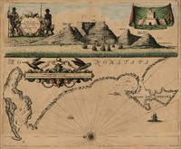
A draught of Cape Bona Esperanca
Coloured chart. Line scale given. Title within decorated cartouche is in top left corner & in top right is an inset of a fort; running across the top of the map is a view of Table Bay. Map has a large decorative scale ... -
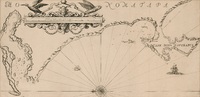
A draught of Cape Bona Esperanca
Chart. Line scale given. Proof copy, - lines drawn to guide the lettering are still there. -
A draught of Cape Bona Esperanca
Chart. Line scale given. This map with some changes is a new ed. of that issued by John Seller in 1675. Seller & Thornton collaborated from 1675 onwards & produced several works including “The English pilot" in which ... -
The Dutch Colony of the Cape of Good Hope
(W. Faden, 1782)Map, coloured border. Line scales given. Depicts an area from Klipping Eyland to Caap Falso bounded on the east by the Draakenstein mountains. Lettered table of place names on the left.