Search
Now showing items 71-80 of 97

A new map of Africa from the latest observations
Coloured map.
Appears in J. Senex: A new general atlas of the world, London, 1721.

L'Afrique
(Hubert Jaillot, 1674)
Coloured map.
Line scale given.
Title above top border: L'Afrique distinguée en ses principales parties...

A new map of Africa from the latest authorities
(J. Cary, 1805)
Coloured map.
Scale not given.

A map of Zaara. Negroe-land. Guinea & c.
Coloured map on sheet.
Lower half of a sheet with "Barbary and Bildurgerid"; on verso, "Africa."
Page number top left, 134, headed "Africa".
Inset: The Isles of C. Verd.
This sheet of maps (uncoloured) appears in ...

Africae propriae tabula
Coloured map.
Scale not given.
First appeared in theatrum orbis terrarum, Addimentum IV (parergon) of 1591.
At the bottom of the map in 2 decorated insets are a plan of Carthage and a list of sources.
Latin text on ...
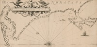
A draught of Cape Bona Esperanca
Chart.
Line scale given.
Proof copy, - lines drawn to guide the lettering are still there.

L'Afrique
Coloured map.
Scale not given.
"Possibly from the maps accompanying Du Val's "Geographia universalis", pub. in Nuremberg in 1685", Johannesburg Pub. Lib: Exhibition of decorative maps of Africa up to 1800, 1952, descriptive ...

Africa
(Cadell & Davies, 1811)
Coloured map.
Scale not given.

Isle d'Auphine
Coloured map.
Line scale given.
Appears (uncoloured) in E. Klemp: Africa on maps dating from the 12th to the 18th century, 1968 (No. 73).

De l'Afrique
Coloured map.
Scale not given.
On either side of map is a description of Africa in French which is headed "De l'Afrique.” A plain map with no decoration, no title or indication of its author or source. In southern Africa ...