Browsing Images by Issue Date
Now showing items 1-20 of 3881
-
Paskaart van de Zuyd-west-kust van Africa
(Jodocus Hondius, 1652)Coloured chart. Line scale given for inset. Inset in top left corner has no title but is an enlarged chart of the coast between St. Helena & False Bay. Smaller inset next to it, is an enlargement of Vlees (Mossel) Bay. ... -
Basse Aethiopie
(P. Mariette, 1655)Coloured map. Scale not given. In lower right corner: I Somer Pruthenus sculp. -
L'Afrique
(Hubert Jaillot, 1674)Coloured map. Line scale given. Title above top border: L'Afrique distinguée en ses principales parties... -
La Seigneurie d'Ouest-Frise ou Frise Occidentale divisée en ses Trois Parties
(H. Jaillot, 1692)Coloured map. Line scale given. Col. cartouche in bottom right corner. -
Carte de l'Afrique meridionale
(Nicolas Visscher, 1710)Coloured map. Line scale given. 3 insets: 1, "Elevation du port et Mont Table au Cap de Bonne Esperance." - 2, "Plan du port et Mont Table au Cap de Bonne Esperance." - 3, in the right hand lower corner is an enlarged ... -
Nieuwe Kaart van de Kaap der Goede Hoope en der na by gelegen Landen
(Is. Tirion, 1763)Coloured map. Line scale given in bottom left corner in "Fransche Toises, of halve Roeden." This map (uncoloured) appears in "Hedendaagsche historie of tegenwoordige staat van Afrika", pub. Amsterdam, I. Tirion, 1763, p.683. -
Africa according to Mr. D'Anville
(Robert Sayer, 1772)Coloured map. Line scales given. Insets: Azores, and A chart of the Gold Coast; Long geographic descriptions (incl. full particulars about the Cape) are placed in every available space. Geographically this map is practically ... -
The Dutch Colony of the Cape of Good Hope
(W. Faden, 1782)Map, coloured border. Line scales given. Depicts an area from Klipping Eyland to Caap Falso bounded on the east by the Draakenstein mountains. Lettered table of place names on the left. -
A plan of Cape Bona Esperance
(Laurie & Whittle, 1794)Chart. Line scale given. Simple cartouche in centre & above it 6 "Views of the land". There are no decorations but an 8 point compass rose drawn in the bay. Inset: "Advertisement" to right of cartouche, giving information ... -
-
Africa, from the latest authorities
(Bungay, Suffolk : C. Brightly & E. Kinnersley, 1806)Coloured map. Scale not given. -
Algemeene kaart, van de Colonie de Kaap de Goede Hoop
(Mortier Covens en Zoon, 1806)Coloured map. Line scale given. This may be an enlargement of the map which appears in B.P. Bouchenroeder: Reize in de Binnenland van Zuid-Afrika, 1803. Mortier Covens en Zoon, 1806. -
-
Africa
(Wilkie & Robinson, 1811)Coloured map. Scale not given. In lower left corner: J. Russell del. et sculp. -
A map of the European territory of the Cape of Good Hope
(H. Colburn, 1815)Map of the Cape of Good Hope. -
Southern Africa
(Longman, Rees, Orme, Brown & Green, 1828)Coloured map. Line scales given. Page number [?] top right: 40; plate number [?] bottom right: XI. -
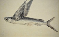
Vlieënde vis 12 Jan.
(1828) -
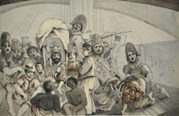
Ewenaardoopseremonie
(1828) -
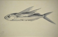
Vlieënde vis 23 Jan.
(1828) -
South Africa
(Society for the Diffusion of Useful Knowledge, 1834)Map. Engraved by J. & C. Walker Insets: "Environs of the Cape.-District of George.- Environs of Grahams Town.- Cape Town from Greig's Almanac”.